I've let this place languish for far too long, but I couldn't let this pass without mentioning it here (though I should have mentioned it sooner!):
Back in August, 2009, I posted some videos I had made from my cycling GPS tracks. Shortly after, in September, I was interviewed by the Torontoist blog.
Most recently, the videos were noticed by Patrick Macaulay at the Harbourfront Centre here in town, and I was invited to participate in a small exhibit called Plotting A City: "Eight artists document the city through an active plotting by creative activities such as photography, painting, sound, walking and installation."
The reception is tonight, 6-10pm, at York Quay, and the show opens tomorrow, January 29th, to run through to April 3rd:
I had no idea that this was a possibility when I posted the videos to YouTube. I'm off to the reception shortly -- I'm looking forward to seeing how it all works out.
Read more!
Friday, January 28, 2011
Friday, December 18, 2009
Cycling: 10,000,000 Meters Maps
According to my GPS logs, this Tuesday I reached 10,000km of cycling since I started recording my rides -- which was when I started riding a recumbent, a Rans V-Rex, on June 25th, 2004. I hadn't been cycling for a few years at that point. A pulled muscle in my back made riding for more than a half-hour or so rather unpleasant, but the recumbent did away with that problem.
The 10,000km has been over 1239 rides taking about 727 hours total, which is a lot of time to spend on a bike. You can see why a recumbent helps.
I rode about 955km that first summer, but this last year -- starting early (February 10th) and riding late (Dec 15th) I got in well over three times that distance (3179km). 3839km of my overall total has been for 1011 rides under 10km (mostly commuting to and from work), 1811 for rides over 50km, and the rest in-between.
My longest ride so far is still the 2008 Hamilton ride, 177km, though I've put in a few centuries since then.
On May 8th, 2007, I upgraded to an HP Velotechnik Streetmachine Gte, which has been my bike every since. Overall, 2972km has been on the V-Rex, 6894 on the Streetmachine, and the rest on Lori's trikes, the Sun EZ-3 and the Catrike Speed.
As I mentioned in a previous post, I've been making maps and animations of my rides. Here are a couple of the latest:

Downtown Toronto

Toronto
These leave out my rides in Missisauga, Hamilton, Bruce County, and Haliburton, but those are a relatively small part of the total.
All-in-all, it's a nice milestone... Though the fact that cyclists in the Ride Across Amierca do half that distance in about nine days puts it in perspective. Read more!
Tuesday, December 15, 2009
Cycling: 10,000,000 Meters
Today, on the way home from work, I hit 10,000km of recumbent cycling since I started in the summer of 2004.
But I think it's time to put the bike away for the winter.
I'll post some maps tomorrow. Read more!
But I think it's time to put the bike away for the winter.
I'll post some maps tomorrow. Read more!
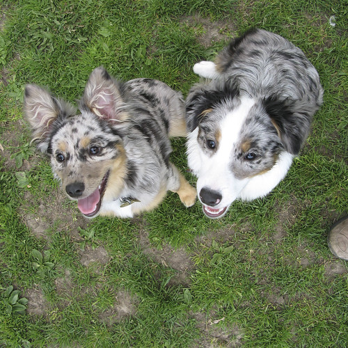
Denim: Happy Birthday
Two years ago yesterday, Denim looked like this:
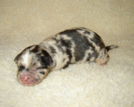
A couple of weeks later -- almost Christmas -- she still looked like a guinea pig:

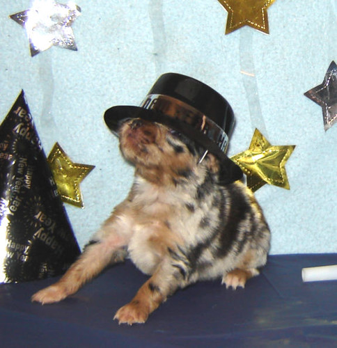
By New Years, she started looking more like an actual dog:
Then we introduced her to Cobalt:

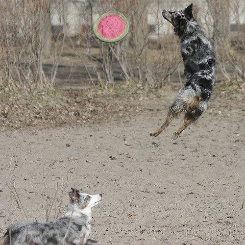
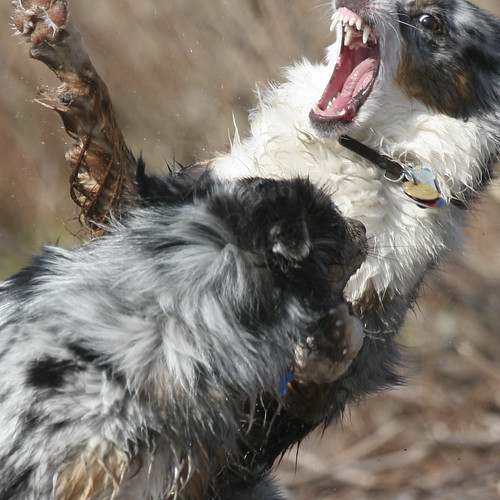
They hit it off immediately:

They became inseparable:

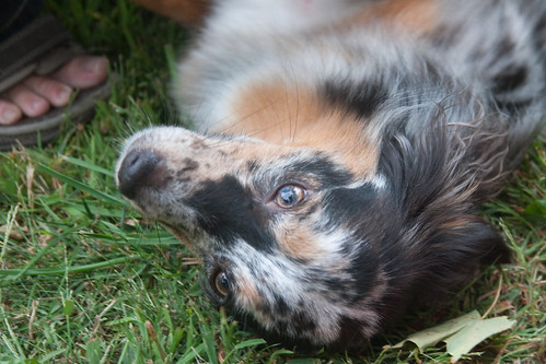
Now she's our acrobat:
She's a complete goofball:

But very sweet:
Read more!
A couple of weeks later -- almost Christmas -- she still looked like a guinea pig:
By New Years, she started looking more like an actual dog:
Then we introduced her to Cobalt:
They hit it off immediately:
They became inseparable:
Now she's our acrobat:
She's a complete goofball:
But very sweet:
Thursday, November 19, 2009
Cobalt: Happy Birthday Photon, Also
And happy birthday to Cobalt's litter-mate Photon, from Chez PLJ:
And thanks to Laura from Chez PLJ for sending the pre-adoption Cobalt pictures. Read more!
And thanks to Laura from Chez PLJ for sending the pre-adoption Cobalt pictures. Read more!
Cobalt: Happy Birthday
Three years ago today, Cobalt looked like this:

A week later, she still looked like a guinea pig:

After four weeks -- almost Christmas -- she started looking more like an actual dog:

At six weeks, it was New Years, and she really started to look like our pup:


We picked her up from Stoverly Aussies on February 11th, when she looked like this:

And now, she's all grown up:

Read more!

A week later, she still looked like a guinea pig:

After four weeks -- almost Christmas -- she started looking more like an actual dog:

At six weeks, it was New Years, and she really started to look like our pup:


We picked her up from Stoverly Aussies on February 11th, when she looked like this:
And now, she's all grown up:
Thursday, September 10, 2009
Cycling: Cycling Routes
Just a quick note that I've added a link to a page with links to the Bikely and MapMyRide maps of my major cycling trips down at the bottom of the page. As I go new rides, I'll be updating that page with maps.
Read more!
Read more!
Tuesday, September 01, 2009
Cycling: Route Maps
I've uploaded maps of some of my longer rides to MapMyRide. MapMyRide has a lot of nice features, but is rather ad-heavy. I'm also going to try Bikely, which doesn't have as many ads, but doesn't have as many features either. Once I've settled on one, I'll throw a permanent link up on the blog.
BTW, I'm experimenting with the "Read More!" feature so that I can hide the bulk of these posts, so you don't have to scroll down through several screens to get to the previous post. Please let me know if there are problems!
(These maps are trimmed at each end so as not to broadcast exact home location to the world.)
First up, my old standby: the Beaches/Taylor Creek/Don Valley loop.
A Don Valley/Humber River loop. This eventually got expanded northward to become my first metric century.
My first time riding the Black Creek ravine trails.
A loop out to Etobicoke Creek by way of the Belt Line and the Eglinton bike trails.
Another Etobicoke Creek loop, this one incorporating the upper creek as well as the lower.
My first time riding in Scarborough. The Highland Creek trail is great, though last time I was there part of it had washed away.
Another ride out into Scarborough. This one is one-way because I forgot to eat breakfast and ran out of energy. I had to get a ride back.
A ride the full length of the Don Valley Trail. This one is one-way because I got caught in a thunder storm and had to get a ride back.
This was my first 100+km ride, incorporating the Don Valley and Humber River trails.
My second 100+km ride, this time through Scarborough.
A good ride from Toronto to Port Credit. This was a precursor to my Hamilton ride.
The big Hamilton ride.
The Tour of Toronto ride.
This one is also up on Bikely:
Sunday's Canada's Wonderland ride.
And here are some out-of-town rides:
A short loop on the Bruce Peninsula.
A very hilly ride from the Red Umbrella Inn on Twelve Mile Lake into Haliburton.
Read more!
Cycling: Interviewed
Stephen Michalowicz of Torontoist has posted a short article about my ride animations: The Cyclist Who Drew Toronto.
Ignore the "Read More!" -- it doesn't apply here. Anyone know how to turn it off for short posts?
Read more!
Ignore the "Read More!" -- it doesn't apply here. Anyone know how to turn it off for short posts?
Read more!
Monday, August 31, 2009
Cycling: Canada's Wonderland
After the Tour of Toronto, I got to thinking that I'd done very little cycling outside the city's boundarys (except along the lake towards Hamilton), and started wondering what the trails were like north of Steeles.
During the Toronto Tour, I came across a sign for the Bartley Smith Greenway, which seemed a good place to start. The trail runs north from Steeles directly across from G. Ross Lord Park, which I'd only biked through once before, so it seemed a good place to start. Using Google Earth, I eyeballed where the trails went and how they connected -- or how to get between them if they didn't connect -- and put together a route that ran north from about the 401/Allen Expresssway interchange all the way up to Canada's Wonderland, then south again by way of Black Creek and the Humber River.
I ended up tweeting the ride again, though without as many photos as the Toronto tour:
11:15 AM Aug 30th: Trying a new cycling route. Let's see how this goes...
The first part of the ride was very familiar: up through Rosedale then along the Belt Line Trail to the Allen Expressway. North from the Allen was moderately familiar -- there isn't really a bike trail there, so it's all residential streets.
12:11 PM Aug 30th: Ok, reached the new part of the route. Time to not get myself lost.
Now I was at Baycrest Park, which I hadn't ridden through before. This was supposed to connect to a series of valley trails that would take me up to G. Ross Lord Park.
12:39 PM Aug 30th: First time through Earl Bales park. Really nice trail - well forested.
This was a great trail. I wish the Don Valley and Rosedale Golf Clubs didn't keep this trail from connecting to the West Don. That'd be a great route.
12:57 PM Aug 30th: Note to self: next time, don't use the trail behind the Jewish Centre on the West Don to get out of the valley...
First big mistake in the plan. Google Earth shows a trail behind the Jewish Community Centre of Toronto on Bathrust. Well, the trail is there... But it runs up a steep climb and is paved entirely with coarse gravel. Completely unmanagable on my recumbent. I ended up walking that climb.
1:18 PM Aug 30th: This is not that helpful:
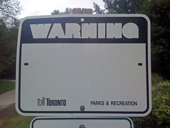
This is in G. Ross Lord Park, which has great wooded trails. I have no idea what it's supposed to be warning against.
1:19 PM Aug 30th: This is, though:
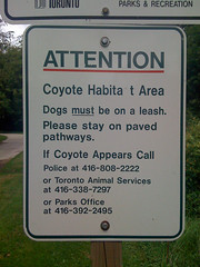
I didn't see any, though.
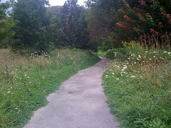
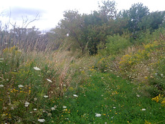
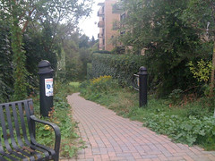
1:26 PM Aug 30th: Great creek-side trail in G. Ross Lord park:
After a stretch in the woods, the trail moves to a wide-open flood plain. This trip largely alternated between woods, meadows, and streets, in a pretty nice balance.
1:32 PM Aug 30th: Last time I was here, I said I'd have to investigate. So, time to do so!
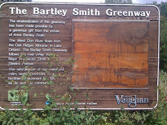
The sign for the Bartley Smith Greenway that I saw during the Tour of Toronto ride. This marks the start of my first real ride north of Steeles (as opposed to those short jaunts into parking lots to grab lunch with in 100m of the street).
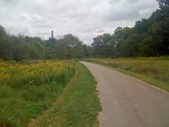
1:50 PM Aug 30th: Nice trail:
The Greenway didn't disappoint, except for being too short. It only ran maybe half a kilometer on a diagonal from Steeles to Dufferin. Fortunately, other trails picked up where it left off. On the west side of Dufferin, the trails in Marita Paine Park and Geln Shields Park actually have tunnels running under the suburban roads so that pedestrians and cyclist barely have to worry about traffic at all.
1:52 PM Aug 30th: First time biking past the 407:
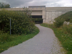
My prefered way of crossing a major freeway on a bike: along a dedciated path underneath.
2:11 PM Aug 30th: This looks less overgrown on Google Earth:
The second major failure in the plan: this looks like a paved path on Google Earth. It's the winding path that runs up between the trees in this view:
It turns out it's kind of abandoned. I could follow the trail for about 200m, but eventually it was so badly overgrown -- and so infested with mosquitos -- that I picked up my bike and hauled it straight through the trees. I just happened to meet the fece for the lot behind the big rectangular building on Basaltic at a point where it was partly collapsed, and I could get the bike over it. Unfortunately, I discovered later that I broke my bell in the process...
2:23 PM Aug 30th: Note to self: when planning a ride using Google Earth, remember that some roads might not exist anymore...
This is important to remember.
2:39 PM Aug 30th: Odd little house:
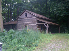
All I know about this house is that it's behind a fence at the east end of a wooded area called Cromwell Park.
3:07 PM Aug 30th: Reached the north end of the ride. It's downhill from here!
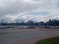
Actually, this is slightly south of the northernmost end of the ride. But it's the official terminus.
From Canada's Wonderland, I just took Creditstone Road south all the way to the 407. Normally, I'm not that fond of riding on suburban industrial roads, but Sunday was very nicely overcast, which took care of my biggest gripe -- the lack of shade. Throw in almost no traffic and a slight downhill grade, and I just zipped along.
3:44 PM Aug 30th: Crossing 407 again.
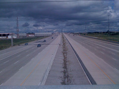
My least favourite way of crossing a major freeway on a bike: on a busy overpasss with a strong cros-wind.
3:53 PM Aug 30th: Back in Toronto: Black Creek Pioneer Village cemetery.
I realized a little after this that I should have gone along Steeles for a block and into the Black Creek valley from Murray Ross Parkway, rather than down Jane to Shoreham. Oh well, next time.
4:12 PM Aug 30th: Another great creek trail: Black Creek
Yet again another great wooded trail. My only gripe with Black Creek -- and it applies to a number of other ravine trails in Toronto -- is that there are a number of places where you have to climb a steep grade up to a busy road, get across, and ride down a steep grade on the other side. A tunnel would be much more convenient -- and safer.
4:32 PM Aug 30th: Nasty climb:
This is the climb from Downsview Dells Park to Langholm Drive, but the picture doesn't do it justice. For starters, the first 50m of the trail from the Downsview Dells parking lot isn't paved -- it's practically marsh. Unridable. Then the climb out of the park is a killer.
4:39 PM Aug 30th: A nice, short trail between cul-de-sacs: Giovanni Caboto Park
I'd never ridden this park before. Google Maps labels this Tavistock Park at the start, then Exbury Park further down, though the sign across from where I entered said Giovanni Cabotto. Whatever the name is, it's a nice ride, though, again, only a few hundred meters long. You come out of the woods and connect to the Heathrow and Chalfkarm Greenbelts, which are trails through standard, open parks.
5:14 PM Aug 30th: I always have trouble spotting this entrance to the Humber trail:
On the Humber, you can get from Steeles to the lake entirely on paved multi-use paths, except for a 600m stretch from Fairglen Crescent to Conron Place. A combination of a steep cliff on the east bank and the Weston Golf & Country Club on the west bank has prevented the city connecting the two sections.
5:23 PM Aug 30th: The remains of Raymore Bridge, destroyed in 1954 by Hurricane Hazel, along with many valley houses:
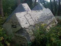
This is one of my favourite "sculptures" in Toronto. It's one of the anchor blocks of the Raymore Bridge, yanks halfway out of the ground by Hurricane Hazel in 1954. The block has been etched with a drawing of the original bridge on the long side (on the right in the photo), and has had reproductions of newspaper front pages from the aftermath mounted on the short side.
Before Hazel, this flood plain had been built up with several houses. The rain from the storm raised rivers' water level by as much as eight meters, and 14 homes in this area were washed away. 81 Canadians were killed by the hurricane, and 35 of those lived just across the river from this marker, where the Raymore Bridge used to go.
After Hazel, Toronto banned building on the flood plains, which is one of the reasons why we have these great ravine parks today.
5:48 PM Aug 30th: Speaking of storms...
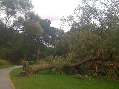
A tree knocked over in one of the recent thunderstorms, possibly the one that spawned all the tornadoes across southwestern Ontario.
5:49 PM Aug 30th: One tree knocked down the next:
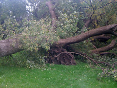
On closer inspection, I realized that the tree in the previous photo was actually two trees: the one had fallen on the other.
6:08 PM Aug 30th: The home stretch! Hope I don't run into Caribana this time...
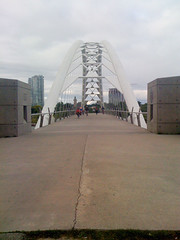
I return to the Humber River Bridge -- from here on home, I'm practically coasting.
6:56 PM Aug 30th: All done! ~95 km, not a bad ride.
And here's the whole thing. I'm trying out an online service called "MapMyRide" for sharing my rides. It's pretty good, but ad-heavy unless you spring for the paid membership. We'll see how it works out:
This map gives the length as 86.91km instead of 95km because I trimmed off the ends (so as not to give directions right to my house) and cut out a few wrong turns and dead ends. The "Dirt" markers are the two places where I ran into unpaved trails, and the red mountain marks the muddly climb out of Downsview Dells Park.
Read more!
During the Toronto Tour, I came across a sign for the Bartley Smith Greenway, which seemed a good place to start. The trail runs north from Steeles directly across from G. Ross Lord Park, which I'd only biked through once before, so it seemed a good place to start. Using Google Earth, I eyeballed where the trails went and how they connected -- or how to get between them if they didn't connect -- and put together a route that ran north from about the 401/Allen Expresssway interchange all the way up to Canada's Wonderland, then south again by way of Black Creek and the Humber River.
I ended up tweeting the ride again, though without as many photos as the Toronto tour:
11:15 AM Aug 30th: Trying a new cycling route. Let's see how this goes...
The first part of the ride was very familiar: up through Rosedale then along the Belt Line Trail to the Allen Expressway. North from the Allen was moderately familiar -- there isn't really a bike trail there, so it's all residential streets.
12:11 PM Aug 30th: Ok, reached the new part of the route. Time to not get myself lost.
Now I was at Baycrest Park, which I hadn't ridden through before. This was supposed to connect to a series of valley trails that would take me up to G. Ross Lord Park.
12:39 PM Aug 30th: First time through Earl Bales park. Really nice trail - well forested.
This was a great trail. I wish the Don Valley and Rosedale Golf Clubs didn't keep this trail from connecting to the West Don. That'd be a great route.
12:57 PM Aug 30th: Note to self: next time, don't use the trail behind the Jewish Centre on the West Don to get out of the valley...
First big mistake in the plan. Google Earth shows a trail behind the Jewish Community Centre of Toronto on Bathrust. Well, the trail is there... But it runs up a steep climb and is paved entirely with coarse gravel. Completely unmanagable on my recumbent. I ended up walking that climb.
1:18 PM Aug 30th: This is not that helpful:
This is in G. Ross Lord Park, which has great wooded trails. I have no idea what it's supposed to be warning against.
1:19 PM Aug 30th: This is, though:
I didn't see any, though.
1:26 PM Aug 30th: Great creek-side trail in G. Ross Lord park:
After a stretch in the woods, the trail moves to a wide-open flood plain. This trip largely alternated between woods, meadows, and streets, in a pretty nice balance.
1:32 PM Aug 30th: Last time I was here, I said I'd have to investigate. So, time to do so!
The sign for the Bartley Smith Greenway that I saw during the Tour of Toronto ride. This marks the start of my first real ride north of Steeles (as opposed to those short jaunts into parking lots to grab lunch with in 100m of the street).
1:50 PM Aug 30th: Nice trail:
The Greenway didn't disappoint, except for being too short. It only ran maybe half a kilometer on a diagonal from Steeles to Dufferin. Fortunately, other trails picked up where it left off. On the west side of Dufferin, the trails in Marita Paine Park and Geln Shields Park actually have tunnels running under the suburban roads so that pedestrians and cyclist barely have to worry about traffic at all.
1:52 PM Aug 30th: First time biking past the 407:
My prefered way of crossing a major freeway on a bike: along a dedciated path underneath.
2:11 PM Aug 30th: This looks less overgrown on Google Earth:
The second major failure in the plan: this looks like a paved path on Google Earth. It's the winding path that runs up between the trees in this view:
It turns out it's kind of abandoned. I could follow the trail for about 200m, but eventually it was so badly overgrown -- and so infested with mosquitos -- that I picked up my bike and hauled it straight through the trees. I just happened to meet the fece for the lot behind the big rectangular building on Basaltic at a point where it was partly collapsed, and I could get the bike over it. Unfortunately, I discovered later that I broke my bell in the process...
2:23 PM Aug 30th: Note to self: when planning a ride using Google Earth, remember that some roads might not exist anymore...
This is important to remember.
2:39 PM Aug 30th: Odd little house:
All I know about this house is that it's behind a fence at the east end of a wooded area called Cromwell Park.
3:07 PM Aug 30th: Reached the north end of the ride. It's downhill from here!
Actually, this is slightly south of the northernmost end of the ride. But it's the official terminus.
From Canada's Wonderland, I just took Creditstone Road south all the way to the 407. Normally, I'm not that fond of riding on suburban industrial roads, but Sunday was very nicely overcast, which took care of my biggest gripe -- the lack of shade. Throw in almost no traffic and a slight downhill grade, and I just zipped along.
3:44 PM Aug 30th: Crossing 407 again.
My least favourite way of crossing a major freeway on a bike: on a busy overpasss with a strong cros-wind.
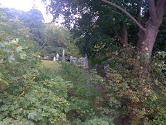
3:53 PM Aug 30th: Back in Toronto: Black Creek Pioneer Village cemetery.
I realized a little after this that I should have gone along Steeles for a block and into the Black Creek valley from Murray Ross Parkway, rather than down Jane to Shoreham. Oh well, next time.
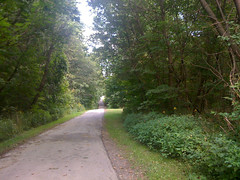
4:12 PM Aug 30th: Another great creek trail: Black Creek
Yet again another great wooded trail. My only gripe with Black Creek -- and it applies to a number of other ravine trails in Toronto -- is that there are a number of places where you have to climb a steep grade up to a busy road, get across, and ride down a steep grade on the other side. A tunnel would be much more convenient -- and safer.
4:32 PM Aug 30th: Nasty climb:
This is the climb from Downsview Dells Park to Langholm Drive, but the picture doesn't do it justice. For starters, the first 50m of the trail from the Downsview Dells parking lot isn't paved -- it's practically marsh. Unridable. Then the climb out of the park is a killer.
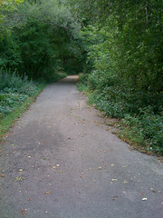
4:39 PM Aug 30th: A nice, short trail between cul-de-sacs: Giovanni Caboto Park
I'd never ridden this park before. Google Maps labels this Tavistock Park at the start, then Exbury Park further down, though the sign across from where I entered said Giovanni Cabotto. Whatever the name is, it's a nice ride, though, again, only a few hundred meters long. You come out of the woods and connect to the Heathrow and Chalfkarm Greenbelts, which are trails through standard, open parks.
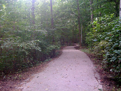
5:14 PM Aug 30th: I always have trouble spotting this entrance to the Humber trail:
On the Humber, you can get from Steeles to the lake entirely on paved multi-use paths, except for a 600m stretch from Fairglen Crescent to Conron Place. A combination of a steep cliff on the east bank and the Weston Golf & Country Club on the west bank has prevented the city connecting the two sections.
5:23 PM Aug 30th: The remains of Raymore Bridge, destroyed in 1954 by Hurricane Hazel, along with many valley houses:
This is one of my favourite "sculptures" in Toronto. It's one of the anchor blocks of the Raymore Bridge, yanks halfway out of the ground by Hurricane Hazel in 1954. The block has been etched with a drawing of the original bridge on the long side (on the right in the photo), and has had reproductions of newspaper front pages from the aftermath mounted on the short side.
Before Hazel, this flood plain had been built up with several houses. The rain from the storm raised rivers' water level by as much as eight meters, and 14 homes in this area were washed away. 81 Canadians were killed by the hurricane, and 35 of those lived just across the river from this marker, where the Raymore Bridge used to go.
After Hazel, Toronto banned building on the flood plains, which is one of the reasons why we have these great ravine parks today.
5:48 PM Aug 30th: Speaking of storms...
A tree knocked over in one of the recent thunderstorms, possibly the one that spawned all the tornadoes across southwestern Ontario.
5:49 PM Aug 30th: One tree knocked down the next:
On closer inspection, I realized that the tree in the previous photo was actually two trees: the one had fallen on the other.
6:08 PM Aug 30th: The home stretch! Hope I don't run into Caribana this time...
I return to the Humber River Bridge -- from here on home, I'm practically coasting.
6:56 PM Aug 30th: All done! ~95 km, not a bad ride.
And here's the whole thing. I'm trying out an online service called "MapMyRide" for sharing my rides. It's pretty good, but ad-heavy unless you spring for the paid membership. We'll see how it works out:
This map gives the length as 86.91km instead of 95km because I trimmed off the ends (so as not to give directions right to my house) and cut out a few wrong turns and dead ends. The "Dirt" markers are the two places where I ran into unpaved trails, and the red mountain marks the muddly climb out of Downsview Dells Park.
Read more!
Subscribe to:
Posts (Atom)