(Note: the maps in this post are all interactive Google Maps, so you can zoom in and scroll around to see the fine details of the routes, or switch to satellite mode to see what buildings I passed.)
I'd been planning this ride for a while. My longest ride to date had been 115km. This was going to be at least 50% longer than that, so I had to be prepared. The first step was picking Hamilton as a destination -- the route is along the lake front, so there aren't too many hills to tire me out. After that, the question was whether to go the longer way, around the west side of Burlington Bay (past tye Royal Botanical Gardens), or to go along the beaches under the Burlington Skyway, on the east side of the bay? I decided to do both -- one on the way in, and the other on the way back.
I arranged with a friend who lives in Hamilton to drop by between noon and 1:00 for lunch, so I could catch my breath for the return trip. I wasn't sure, even as I set out, wether I wanted to do the western route going in (it's hilly, so I might have been too tired after biking that far) or save it for going back after I'd had something to eat. I decided to make up my mind when I got to Burlington.
The route I took is based on the Waterfront Trail, which runs (on and off) from Kingston to Niagara Falls. It's uninterupted from the Beaches in Toronto to Stoney Creek in Hamilton, though it alternates between dedicated off-road multi-use trails and simply using Lakeshore Boulevard -- between Port Credit and Burlington, it's almost entirely on Lakeshore.
The first leg (above) was very familiar to me -- I'd done the Toronto-to-Port Credit ride several times. I stopped in Etobicoke for breakfast (I learned my lesson about eating early in a long ride a couple of years ago, when I conked out after 55km without a breakfast, still 20km from home).
From Etobicoke, the trail runs along Lakeshore for a while, then cuts down to the water to alternate between parks and neighbourhood streets all the way to Port Credit.
On the west side of Port Credit the trail goes into a large park. At the entrance to the park, I encountered this sign (first flag on the map):

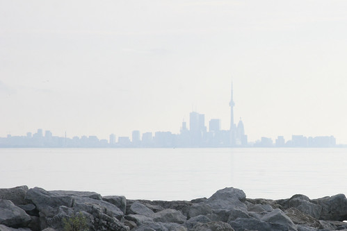
Further along is Jack Darling Memorial Park, where I saw a couple looking intently at something in the grass (second flag). As I got closer, I realized it was a hawk which had caught a starling. Unfortunately, the hawk took off before I could get the camera out. Instead, I took a photo back at downtown Toronto
The Jack Darling path leads into Rattray Marsh, but the trail turns to sand as you enter, so I decided to go around, though the neighbourhood. This involved the first noticable climb of the ride, though nothing major.
The the next while, the path was pretty straightforward -- long stretches of Lakeshore Boulevard, with the occasional dips over to the water in the parks around town centres.
When I got to Burlington, I was still feeling reasonably fresh, so I decided to take the hilly route around the east side of Burlington Bay. The route continued much as it had, though I got a little mixed up in my directions at one point (first flag) and ended up on a steep, sandy path that I couldn't quite force the bike up.
By this point, I was getting a little tight on time -- I promised my friend I'd be at his place for lunch around noon -- so I decided to forgo the route through the Royal Botanical Garden, and head straight downs Sping Gardens Road to get to York Boulevard.
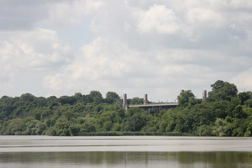
The first part of this was easy -- a downhill run to Valley Inn Road, where I took this photo of the York Boulevard bridge, which runs over the channel between Cootes Paradise (the innermost part of the bay) and Burlington Bay.
The problem was, I had to get back up to cross over that bridge... A 25 metre climb in a run of 300 metres, after having just ridden over 80km from Toronto. Needless to say, I didn't quite make it all the way up, and had to finish the climb on foot.
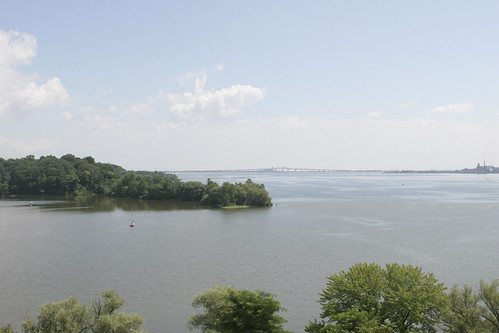
Once up there, and across the bridge, I stopped to photograph the Burlington Skyway -- the route I'd take going back.
Then came the biggest problem of all -- to get back to the Waterfront Trail, I had to get my bike back down 25 metres, and the only route was a set of stairs (second flag). Thoughtfully, they'd included a bike groove, but my recumbent bike doesn't work well in those.
Fortunately, a friendly jogger helped me carry the bike down the eight-or-so flights.

The bridge, as seen from the top of the stairs.
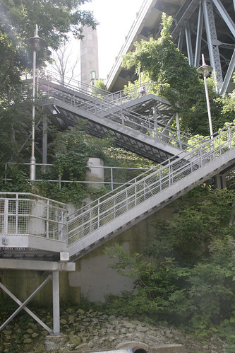
The stairs, seen from the bottom. You can't make out the first three flights, which run from the monolith to the top of the flights you can see.

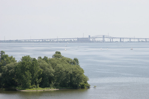
The bridge, as seen from the bottom of the stairs.
From there, it was a short ride along the Waterfront Trail to where I could get onto Hamilton streets, and then another 15 minutes or so to my friend's place. So far, I'd ridden about 95km.
After a nice barbequed lunch, I was on my way again. The return route was about 85km, and without the hills that the trip down had ended with, so I was feeling optimistic. The route started but cutting east across town to Stoney Creek, where I could hook back up with the Waterfront Trail.
Unfortunately, just as I got to Stoney Creek, the city was hit by one of these miserable summer downpours that has been plaguing the area this summer. I had to hole up in a Mac's Milk for 15 minutes or so, until the rain had passed (first flag).
The Waterfront Trail under the Burlington Skyway runs along the east side of the land below the bridge. Bicycles and pedestrians can cross at the lift bridge (second flag), but apart from that the ride is extremely flat and easy.
Once back in Burlington, I was retracing the route I'd taken on the way down. I did make some changes, though: I skipped a few of the smaller detours from Lakeshore Boulevard to the waterfront, and instead of going around Rattray Marsh, I went through.
The trail was pretty good, but at one point, turning a corner, I had the most serious spill I've ever had on my recumbent bike. The limestone path, wet from the downpour, had turned to soft clay on the corner, and my rear wheel slide sideways, taking the entire bike out from under me and dumping me on my tailbone in the mud (flag).
This was more surprising than anything -- it's very hard to get thrown from a recumbent bike. My worst spill ever on a recumbent was far less dangerous than even a mild spill on a standard bike, since it's almost impossible for me to fall head first. Still, it was uncomfortable, and wet. The bike also suffered some minor damage: the bell was totalled, the steering was knocked out of alignment (not by much, only a couple of degrees, but noticable), and the seat was soaked. It was still quite ridable, though, so I was back up and on my way in a few minutes.
I had to walk the bike for the last part of the marsh trail, because it has stairs and ended in that sandy section that had discouraged me from entering the marsh on the way down.
Not long after that, I arrived in Port Credit, and decided to stop for a bite of pizza.
The last leg of the ride was uneventful, though by this time I was starting to wear down. It was almost 12 hours since I'd left the house, and I still had 30km to go.
When I got back across the Humber River, the last complication appeared -- Caribana. On my trip out, I'd passed by the parade route long before festivities were to start, but now the western beaches were packed with celebrants who'd stuck around after the parade ended. The Waterfront Trail was far too busy to ride, so I cut up to the Queensway and rode the rest of the way home on King Street (which was packed solid from Roncesvalles to about Spadina). Finally, around 8pm, I got home. I'd been out for roughly 13 hours, of which 10 were spent on the bike. L & I went out for dinner as my muscles complained about having to be used for walking instead of cycling, and I had a very good night's sleep.
Read more!
")
")
")
")
")
")
")
")
")
")